Inquiry with Imagery: Historical Archive Retrieval with Digital Cameras
Brian K Smith, Erik Blankinship, Alfred Ashford III, Michael Baker
& Timothy Hirzel
MIT Media Laboratory
20 Ames Street
Cambridge, MA 02139 USA
+1 617 253 6537
{bsmith, erikb, coltrane, mbaker, hirzel}@media.mit.edu
Abstract
This paper describes an integration of geographic information
systems (GIS) and multimedia technologies to transform the ways K-12 students
learn about their local communities. We have augmented a digital camera
with a global positioning system (GPS) and a digital compass to record
its position and orientation when pictures are taken. The metadata are
used to retrieve and present historical images of the photographed locations
to students. Another set of tools allows them to annotate and compare these
historical images to develop explanations of how and why their communities
have changed over time. We describe the camera architecture and learning
outcomes that we expect to see in classroom use.
Contents
In most K-12 classrooms, students are exposed to historical
issues through the writings and narrative accounts of others. In general,
they lack primary data sources to complement these writings and allow them
to form their own interpretations of the past. We see opportunities for
students to generate their own explanations of historical trends with archival
photographs. Rather than just relying on captions and narratives to explain
content, we are providing tools for students to annotate and compare historical
images and to detect and explain patterns and relations over time. In this
way, we hope to help them become better observers and critics of the real
world by using imagery as data.
We are developing new ways for students to investigate
the histories of their communities by combining geographic information
systems (GIS) and multimedia technologies. Historical photographs provide
a glimpse at the architectural, fashion, transport, and cultural trends
of a period. When these images are arranged spatially on maps, students
can begin looking for patterns and relations that may vary geographically.
While innovations in multimedia and GIS learning environments have been
documented [e.g.,4, 6], the fusion of the two technologies has not been fully explored.
In this paper, we describe tools for K-12 students to
investigate and explain how and why their communities have evolved over
time. To facilitate student inquiry, we have augmented a digital camera
with a global positioning system (GPS) and a digital compass to record
position and orientation metadata when pictures are taken. When the camera
is downloaded, each augmented picture is used to retrieve historical pictures
of the photographed location using image and GIS databases. By integrating
GIS data with multimedia objects [3, 9], student photographs can be geo-referenced
to provide data for theory construction. By linking students' images of
the present with those of the past, we create a starting point for inquiry
into community change.
To give a sense for the types of activities that we hope
to see, we begin with a hypothetical use scenario, a group of students
exploring their local community. These students use our camera to take
pictures of buildings and settings in their communities that they like
and dislike. After doing so, they return to their classroom and download
their images into our software (Figure 1). The thumbnails on the right
side of the display show students' photographs. When one of these thumbnails
is clicked, its enlarged image appears at right center, and a set of historical
thumbnails matching the location of the selected image is displayed at
the top --- clicking one of these expands its image at the left center. Figure
1 shows how a photograph of Harvard Square in 1999 retrieves nine images
of the same location between 1860 and 1980.
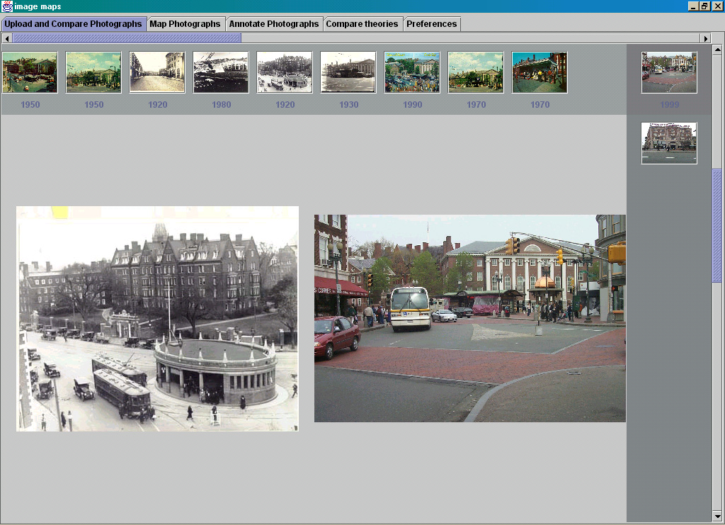 Figure 1: The current retrieval interface. Thumbnails
on the right are images taken by students. Choosing one of these displays
its larger image and an array of historical thumbnails across the top.
The left image is the historical photo chosen from the retrieved collection.
Figure 1: The current retrieval interface. Thumbnails
on the right are images taken by students. Choosing one of these displays
its larger image and an array of historical thumbnails across the top.
The left image is the historical photo chosen from the retrieved collection.
The students now need to explain why they liked or disliked
the objects that they photographed. They do this by creating descriptive
ontologies and labeling objects in the images with these features. For
instance, Figure 2 shows a list of features that students might develop
(e.g., transport types, commercial buildings, road types). The historical
photos are tagged with these labels, and students can begin comparing images
over time to see similarities and differences. As they mark up more photographs,
they can begin to retrieve images using their ontological features and
describe urban planning patterns [1] that have varied or remained consistent
throughout history.
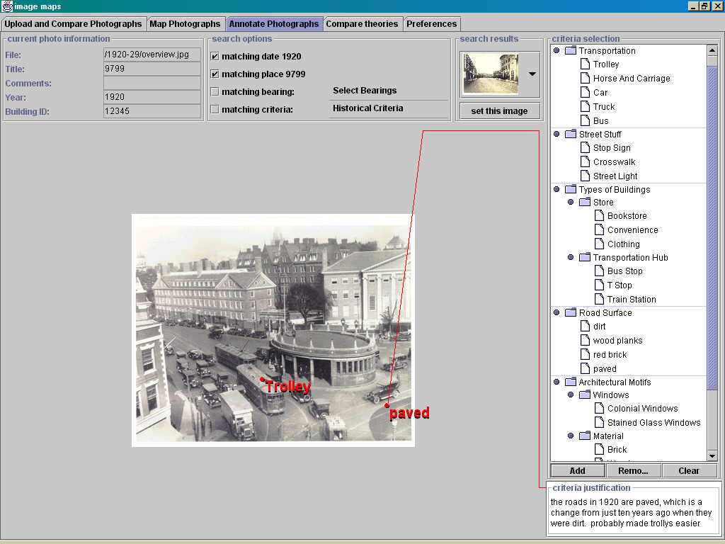 Figure 2: Annotating images. Students develop ontologies
to characterize interesting features of images. Objects in the photographs
are labeled with these features and used to develop explanations of community
change.
Figure 2: Annotating images. Students develop ontologies
to characterize interesting features of images. Objects in the photographs
are labeled with these features and used to develop explanations of community
change.
When students are taught to explore their outdoor surroundings,
they can become more aware of the intricacies of man-made environments [10].
We assist this process by giving access to historical images that might
otherwise go unseen by students. We claim that doing "field work" with
our camera, obtaining a record of local history, and working to explain
the various changes in the community can lead to new insights about historical,
architectural, and social change.
What can you learn from image data?
So rather than providing students with textbook explanations
of history, we adopt a learner-centered approach [e.g., 8] to engage students in
constructing and reflecting on their own explanations of image data. Previous
work [5, 7, 12] has discussed the use of video as data in learning and coordinating
complex tasks. We build on these projects by allowing students to acquire
their own data in the form of photographs, and the annotation tools allow
them to construct theories around issues in urban planning and cultural
change.
In the above scenario, there are a number of ways that
students can learn with historical images provided by the camera. We are
currently working to understand how such learning opportunities can aid
the following:
- Observation and interpretation. Rather than viewing
images as "visual aids" to accompany textual explanations, students are
responsible for drawing conclusions from image data. Comparing images across
time periods can also provide insights into community change.
- Reasoning about urban planning. We want students to
develop hypotheses about the function of architectural structures. For
instance, pedestrian crosswalks appeared rather recently in history. Students
can pinpoint the time when they appeared and develop theories about why
they may have been necessary. For instance, evidence of increased commercial
buildings in the historical images may be correlated with the emergence
of crosswalks (i.e., more commerce leads to more pedestrians).
- Reasoning about culture. Images can provide important
clues about community culture. For instance, a picture containing a "Buy
War Bonds" advertisement is the beginning of a story about America during
World War II. We hope to have students explore the meanings behind cultural
artifacts found in images, possibly by collaborating with older adults
to discover what is was like to live during the 1940's.
- Inquiry is an iterative process. Although students
could browse historical images without the camera, we feel that it is important
for them to do "field work", to visit locations while constructing explanations
of community change. During annotation, students may observe image features
that require further investigation in the field (e.g., they may
want to rethink traffic flows after seeing how roads changed over a period
of time). By returning to the field to generate further observations and
questions, we hope they will better understand the iterative nature of
inquiry.
A Kodak DC260 digital camera has been augmented with a
Trimble Lassen-SK8 GPS and a Precision Navigation TCM2-80 digital compass.
The camera uses Flashpoint Technology's Digita operating environment [2],
allowing it to be scripted to send commands to the sensors through its
serial port and to embed received data into JPEG images (Figure 3).
In this way, the camera's origin and orientation are recorded when pictures
are taken.
 Figure 3: An "out of the box" view of the camera hardware.
A Kodak DC260 digital camera is attached to a Trimble Lassen-SK8 GPS and
a Precision Navigation TCM2-80 digital compass. This hardware configuration
allows recording of position and orientation information into a JPEG image.
A portion of the camera script that sends and receives data from the sensors
and embeds it into the image file is also shown.
Figure 3: An "out of the box" view of the camera hardware.
A Kodak DC260 digital camera is attached to a Trimble Lassen-SK8 GPS and
a Precision Navigation TCM2-80 digital compass. This hardware configuration
allows recording of position and orientation information into a JPEG image.
A portion of the camera script that sends and receives data from the sensors
and embeds it into the image file is also shown.
Our Java application parses the GPS and compass metadata
from downloaded images and uses them to access a spatial map of Cambridge,
Massachusetts stored in Esri Incorporated's ArcView GIS. We start at the
camera's origin and trace the orientation vector until we intersect a building
or other landmark [11]. This raytracing routine approximates line of sight
to return the name of the nearest landmark to the camera lens (Figure 4).
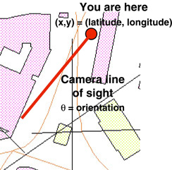 Figure 4: A segment of the ArcView GIS map for Cambridge,
Massachusetts. The large dot shows the current camera position at a GPS
coordinate. Orientation is used to trace a vector from the camera origin
along its line of sight. The current algorithm simply returns the first
building that intersects the line of sight vector.
Figure 4: A segment of the ArcView GIS map for Cambridge,
Massachusetts. The large dot shows the current camera position at a GPS
coordinate. Orientation is used to trace a vector from the camera origin
along its line of sight. The current algorithm simply returns the first
building that intersects the line of sight vector.
A separate Perl database associates each building name
with a set of historical photographs. Each of these images has been hand-indexed
with the position and orientation that it was taken from and the year when
it was taken. The retrieval engine selects and displays images that closely
match the view of the target image. If we cannot find images with similar
shot distances and/or orientations, we relax the constraints and return
any photographs of the location. We currently test our retrieval algorithms
with 1000+ hand-indexed images between Harvard Square and MIT.
We are expanding our image database to provide students
with richer data sources. The algorithm used to retrieve images is still
rather simple, and we are developing a more sophisticated engine. For instance,
the camera currently records tilt information, and we can use that data
to disambiguate target buildings (e.g., photographs of tall buildings
with smaller ones in the foreground). We will also automatically index
student photographs into the image database to create records of the present
that can be used in future classrooms.
We are working towards a new class of visualization and
modeling applications that use imagery as a primary data source for inquiry.
Rather than simply looking at photographs or watching videos, we want to
see students arguing and debating over differences in image data. While
most scientific visualization tools map quantitative data into visual representations,
our students work directly with observational, image data, constructing
qualitative models that can be used to predict future outcomes and events.
The work described here is a first step towards fusing GIS and multimedia
systems to produce new learning experiences through imagery.
Although we have tested the camera ourselves, our first
deployment with children (14-16 years old) begins in August 1999. This
initial deployment will inform the iterative design of the camera and software
tools for constructing explanations about community change. We will also
attempt to understand the types of supports that teachers need to provide
for this activity to successfully engage students in new ways of thinking
We would like to thank the Cambridge Historical Commission
for their gracious donation of 100+ years of historical images. This work
is supported by the MIT Media Laboratory's News in the Future consortium
and kind donations from Eastman Kodak.
-
Alexander, C., Ishikawa, S., & Silverstein, M. (1977).
A Pattern Language: Towns, Buildings, Construction.
Oxford: Oxford University Press.
-
Flashpoint Technology. (1998).
Digita Operating System: Script Reference. San Jose, CA: Flashpoint Technology.
-
Kraak, M.-J. (1996). Integrating
multimedia in geographical information systems. IEEE Multimedia, 3(2):
59-65.
-
McWilliams, H. & Rooney,
P. (1997). Mapping our city: Learning to use spatial data in the middle
school science classroom. Paper presented at the Annual Meeting of the
American Educational Research Association. Chicago, IL.
-
Nardi, B.A., Kuchinsky, A.,
Whittaker, S., Leichner, R., & Schwarz, H. (1996). Video-as-data: Technical
and social aspects of a collaborative multimedia application. Computer
Supported Collaborative Work, 4: 73-100.
-
Pea, R.D. (1991). Learning through
multimedia. IEEE Computer Graphics & Applications, 11(4): 58-66.
-
Smith, B.K. & Reiser, B.J.
(1997).
What should a wildebeest say? Interactive nature films for high
school classrooms. In ACM Multimedia 97 Proceedings (pp. 193-201). New
York: ACM Press.
-
Soloway, E., Guzdial, M., &
Hay, K.E. (1994). Learner-centered design: The challenge for HCI in the
21st century. interactions, 1(2): 36-48.
-
Spohrer, J. (1998). Worldboard:
What comes after the WWW? Available:
http://www.worldboard.org/pub/spohrer/wbconcept/default.html.
-
Stilgoe, J.R. (1998). Outside
Lies Magic: Regaining History and Awareness in Everyday Places. New York:
Walker and Company.
-
Tsui, C. (1998). Multimedia
Data Integration and Retrieval in Planning Support Systems. M.S. thesis.
Department of Urban Studies and Planning, Massachusetts Institute of Technology.
-
Whittaker, S. & O'Conaill, B. (1997).
The role of vision in face-to-face and mediated communication.
In K.E. Finn, A.J. Sellen, & S.B. Wilbur (Eds.), Video-Mediated Communication
(pp. 23-49). Hillsdale, NJ: Lawrence Erlbaum As-sociates.
Copyright © 1999 ACM.
